Identification

Title

Hydrological projections for the UK, based on UK Climate Projections 2018 (UKCP18) data, from the Enhanced Future Flows and Groundwater (eFLaG) project

Abstract

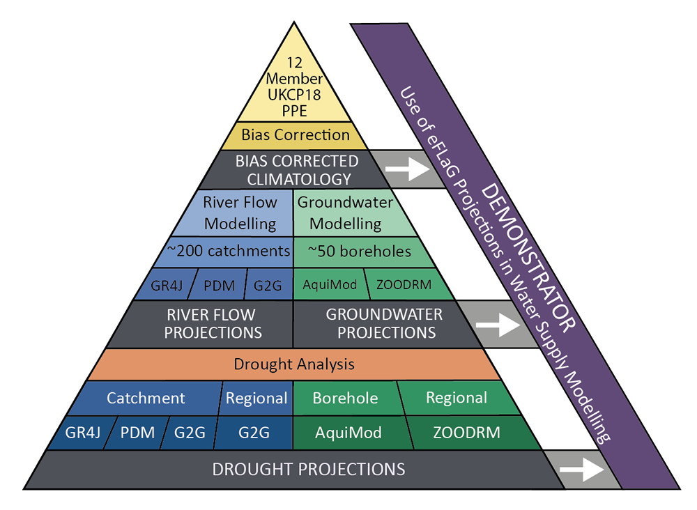
Enhanced Future Flows and Groundwater (eFLaG) is an 12-member ensemble projection of river flow, groundwater level, and groundwater recharge time series for 200 catchments, 54 boreholes and 558 groundwater bodies in Great Britain and Northern Ireland. It is derived from the UKCP18 dataset, specifically the 'Regional' 12km projections, to which a bias correction is applied. River flows, groundwater level and groundwater recharge data are at a daily time step. To be consistent with the driving meteorological dataset, eFLaG data use a simplified 360-day year, consisting of twelve 30-day months. eFLaG data span from 1981 to 2080. The development of eFLaG was made during the partnership project funded by the Met Office-led component of the Strategic Priorities Fund Climate Resilience programme under contract P107493 (CR19_4 UK Climate Resilience). Full details about this dataset can be found at https://doi.org/10.5285/1bb90673-ad37-4679-90b9-0126109639a9

Resource type

dataset

Resource locator

https://catalogue.ceh.ac.uk/datastore/eidchub/1bb90673-ad37-4679-90b9-0126109639a9

name: Download the data

description: Download a copy of this data

function: download

https://data-package.ceh.ac.uk/sd/1bb90673-ad37-4679-90b9-0126109639a9.zip

name: Supporting information

description: Supporting information available to assist in re-use of this dataset

function: information

https://eidc.ceh.ac.uk/images/browsegraphics/eflag.png

name: eFLaG workflow diagram

Unique resource identifier

code

https://catalogue.ceh.ac.uk/id/1bb90673-ad37-4679-90b9-0126109639a9

codeSpace

doi:

Dataset language

eng

Spatial reference system

code identifying the spatial reference system

Classification of spatial data and services

Topic category

inlandWaters

Keywords

Keyword set

keyword value

Environmental Monitoring Facilities

originating controlled vocabulary

title

GEMET - INSPIRE themes, version 1.0

reference date

date type

publication

effective date

2008-06-01

Keyword set

keyword value

Aquifer

Groundwater

Projection

River flow

United Kingdom

Water

Geographic location

West bounding longitude

-8.648

East bounding longitude

1.768

North bounding latitude

60.861

South bounding latitude

49.864

Temporal reference

Temporal extent

Begin position

1981-01-01

End position

2080-12-31

Dataset reference date

date type

publication

effective date

2022-01-26

Frequency of update

Quality and validity

Lineage

Meteorological data is from the UKCP18 dataset, specifically the ‘Regional’ 12km projections. Observed river flow and groundwater level data are provided by the NRFA (National River Flow Archive) and NGLA (National Groundwater Level Archive) respectively. Meteorological and observed data is then modelled through a number of systems including AquiMod, ZOODRM, G2G, PDM, GR4J.

Conformity

Conformity report

specification

title

Commission Regulation (EU) No 1089/2010 of 23 November 2010 implementing Directive 2007/2/EC of the European Parliament and of the Council as regards interoperability of spatial data sets and services

reference date

date type

publication

effective date

2010-12-08

degree

explanation

Data format

name of format

Comma-separated values (CSV)

version of format

Constraints related to access and use

Constraint set

Limitations on public access

Constraint set

Limitations on public access

Constraint set

Limitations on public access

If you reuse this data, you should cite: Hannaford, J., Mackay, J., Ascott, M., Bell, V., Chitson, T., Cole, S., Counsell, C., Durant, M., Facer-Childs, K., Jackson, C., Kay, A., Lane, R., Mansour, M., Moore, R.J., Parry, S., Rudd, A., Simpson, M., Turner, S., Wallbank, J., Wells, S., Wilcox, A. (2022). Hydrological projections for the UK, based on UK Climate Projections 2018 (UKCP18) data, from the Enhanced Future Flows and Groundwater (eFLaG) project. NERC EDS Environmental Information Data Centre https://doi.org/10.5285/1bb90673-ad37-4679-90b9-0126109639a9

Responsible organisations

Responsible party

organisation name

UK Centre for Ecology & Hydrology

email address

enquiries@ceh.ac.uk

responsible party role

author

Responsible party

organisation name

British Geological Survey

email address

enquiries@ceh.ac.uk

responsible party role

author

Responsible party

organisation name

British Geological Survey

email address

enquiries@ceh.ac.uk

responsible party role

author

Responsible party

organisation name

UK Centre for Ecology & Hydrology

email address

enquiries@ceh.ac.uk

responsible party role

author

Responsible party

organisation name

UK Centre for Ecology & Hydrology

email address

enquiries@ceh.ac.uk

responsible party role

author

Responsible party

organisation name

UK Centre for Ecology & Hydrology

email address

enquiries@ceh.ac.uk

responsible party role

author

Responsible party

organisation name

HR Wallingford

email address

enquiries@ceh.ac.uk

responsible party role

author

Responsible party

organisation name

HR Wallingford

email address

enquiries@ceh.ac.uk

responsible party role

author

Responsible party

organisation name

UK Centre for Ecology & Hydrology

email address

enquiries@ceh.ac.uk

responsible party role

author

Responsible party

organisation name

British Geological Survey

email address

enquiries@ceh.ac.uk

responsible party role

author

Responsible party

organisation name

UK Centre for Ecology & Hydrology

email address

enquiries@ceh.ac.uk

responsible party role

author

Responsible party

organisation name

UK Centre for Ecology & Hydrology

email address

enquiries@ceh.ac.uk

responsible party role

author

Responsible party

organisation name

UK Centre for Ecology & Hydrology

email address

enquiries@ceh.ac.uk

responsible party role

author

Responsible party

organisation name

HR Wallingford

email address

enquiries@ceh.ac.uk

responsible party role

author

Responsible party

organisation name

UK Centre for Ecology & Hydrology

email address

enquiries@ceh.ac.uk

responsible party role

author

Responsible party

organisation name

UK Centre for Ecology & Hydrology

email address

enquiries@ceh.ac.uk

responsible party role

author

Responsible party

organisation name

UK Centre for Ecology & Hydrology

email address

enquiries@ceh.ac.uk

responsible party role

author

Responsible party

organisation name

HR Wallingford

email address

enquiries@ceh.ac.uk

responsible party role

author

Responsible party

organisation name

NERC EDS Environmental Information Data Centre

email address

enquiries@ceh.ac.uk

responsible party role

publisher

Responsible party

organisation name

NERC EDS Environmental Information Data Centre

email address

enquiries@ceh.ac.uk

responsible party role

custodian

Responsible party

organisation name

UK Centre for Ecology & Hydrology

email address

enquiries@ceh.ac.uk

responsible party role

owner

Responsible party

organisation name

UK Centre for Ecology & Hydrology

email address

enquiries@ceh.ac.uk

responsible party role

pointOfContact

Responsible party

organisation name

British Geological Survey

email address

enquiries@ceh.ac.uk

responsible party role

owner

Metadata on metadata

Metadata point of contact

organisation name

Environmental Information Data Centre

full postal address

Lancaster Environment Centre, Library Avenue, Bailrigg

Lancaster

LA1 4AP

UK

email address

info@eidc.ac.uk

responsible party role

pointOfContact

Metadata date

2023-02-16T09:52:26

Metadata language

eng